
South Coast Fjords
National Marine Conservation Area (NMCA) & National Park Project
A joint feasibility assessment between Parks Canada, the Government of Newfoundland and Labrador, Miawpukek First Nation, Qalipu First Nation, and the Town of Burgeo to designate a National Marine Conservation Area (NMCA) along the south coast and redesignate Sandbanks Provincial Park as a National Park.

MM
On June 23, 2023 a Memorandum of Understanding (MOU) was signed underlining the shared interest of Parks Canada, the Government of Newfoundland and Labrador, Miawpukek First Nation, Qualipu First Nation and the Town of Burgeo to designate the South Coast Fjord area as a National Marine Conservation Area and redesignate Sandbanks Provincial Park as a National Park to protect the natural and cultural integrity of this area.
A feasibility assessment is currently being undertaken by a steering committee made up of members of the above groups.
The South Coast fjords were chosen for a potential National Marine Conservation Area as this coastline is a very productive marine environment, has a unique geography, and is culturally and historically important to the region’s Indigenous and coastal communities.
Project
Overview
The proposed National Marine Conservation Area study area covers 9,112 square kilometers of coastline from the eastern side of La Poile Bay to the eastern side of McCallum and extends offshore 70 km to the south. This is only the study boundary and may not be the final boundary of the NMCA.
The current boundaries of Sandbanks Provincial Park cover a region of 2.26 square kilometers and is being considered for redesignation as a National Park.
What is a National Marine Conservation Area (NMCA)?
National Marine Conservation Areas (NMCA) are areas established and managed to protect and conserve marine environments and biodiversity, conserve cultural heritage, protect resources for sustainable use, and create enjoyable experiences for locals and visitors.
National Marine Conservation Areas showcase the important relationships that Indigenous peoples and coastal communities have with the marine environment


What is a National Park?
A National Park is created to protect important land and marine habitats, geographical features, and sites of cultural significance, while also creating economic opportunities for people in the community.
The goal of a National Park is to maintain and preserve the environment as it is, and protect it for present and future generations.
The remote south coast fjords are a special and unique region of Newfoundland because of its historical significance, cultural heritage, and its geography. This region has a rich, untapped potential for tourism. A National Marine Conservation Area and National Park will share the natural diversity and cultural history of the South Coast nationally and internationally.
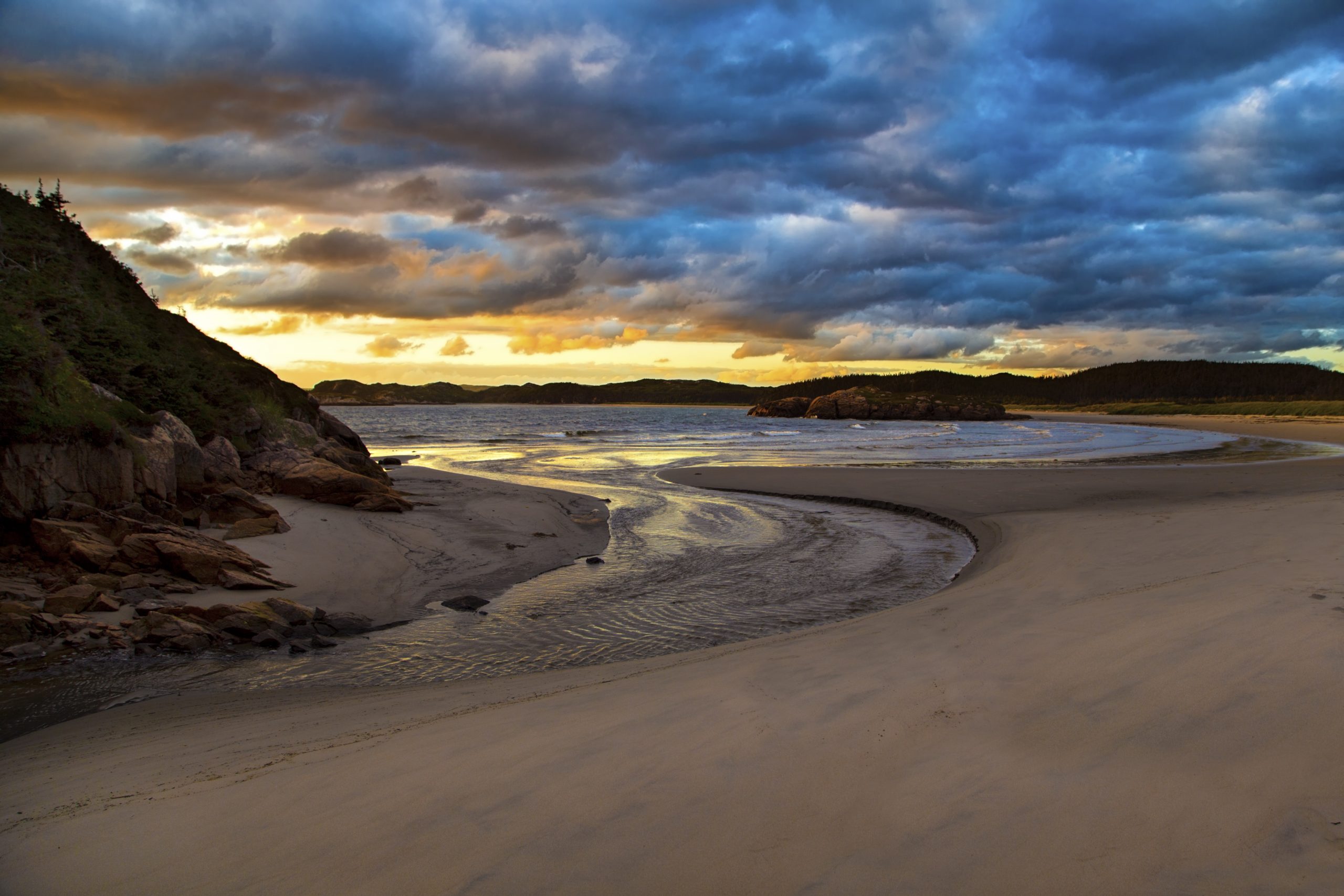
The south coast covers a wide range of ecosystems, this variety in environments is unique to this area. Along the coast, there are 365 islands, large granite cliffs and deep fjords carved by glaciers, sand dunes and beautiful beaches, the Big Barasway Wildlife Reserve, and is part of the South Coast Barrens.
This variety of habitats is home to many plants and animals. Including the endangered piping plover, Common Eider, and Harlequin duck in Sandbanks Provincial Park and the Big Barasway wildlife reserve; protected by the Burgeo Coastal Habitat Stewardship Agreement. The marine environment is a key migration route for over 20 species of whales, and an important habitat for Atlantic cod, leatherback sea turtles, dolphins, porpoises, sharks, and many more! The South Coast Barrens also provide wintering grounds for caribou.
There is also an archeological significance of the coastal islands. The Burgeo Coast Archeological Research project in 1997 found that the region was occupied by Maritime Archaic, Groswater, Dorset, Recent Indian, Paleo-eskimo first nations, and European settlers. There are many artefacts that have been found and these historic archeological sites are very important to protect and use for education.
Why was the South Coast of Newfoundland chosen?
Well… it’s beautiful, we all know that!

Joe Brazil: parksnl

MM
March 6, 2024: Parks Canada Question & Answer Session
In February as preparation for a Question and Answer session, Parks Canada reached out to community members in Burgeo to share their questions and concerns about the South Coast Fjords National Marine Conservation Area and re-designation of Sandbanks Provincial Park as a National Park project.
The Parks Canada staff were very grateful for the amount of questions that the community submitted and felt that it was very helpful in the feasibility assessment phase as it helped them understand where there were uncertainties or misunderstandings, and where it was necessary for them to work to fill knowledge gaps. They took the questions and grouped them by theme.
Watch the recorded Q&A session here
See below for answers to specific questions transcribed from the Q&A session on March 6, 2024. There are also printed versions of this information in the town office if you would find this easier to read.
If anyone feels that their questions haven’t been answered, please reach out to any of the below contacts:
Parks Canada South Coast Fjords project email- fcs-scf@pc.gc.ca
Melissa Mills, Town of Burgeo Community Project Facilitator - facilitator@townofburgeo.com
Town of Burgeo NMCA Steering Committee members
Dr. Barbara Barter
Bill Bowles
Dave MacDonald - Alternate Member
-
The project is entering into the consultation phase of the feasibility study. During this stage, Parks Canada will be engaging with stakeholders throughout the spring and summer to determine information for the feasibility assessment. The goal of the consultation phase is to inform people on what is being accomplished.
This stage is still early in the feasibility assessment process, but at the end, the five signees of the Memorandum of Understanding: Parks Canada, Government of Newfoundland and Labrador, Town of Burgeo, Qalipu First Nations, and Miawpukek First Nations, will determine if this area is the right fit for a National Marine Conservation Area and National Park.
-
In 1996, a regional analysis was completed for Parks Canada that defined the features of the Laurentian Channel Marine Region.
In 2003, a proposal was submitted identifying additional data to suggest that the study area for the proposed South Coast Fjords NMCA was a preferred candidate site for further protection. This area is a good study site as it includes as many representative features as possible.
This project has received continued community support, and on June 23, 2023, a Memorandum of Understanding was signed by the 5 partners to assess the feasibility of establishing an NMCA on the south coast.
The South Coast Fjords NMCA would contribute to Canada’s 2030 Marine Conservation Target to place 30% of Canadian waters under protection by 2030.
-
The steering committee is made up of members of all 5 Memorandum of Understanding signees.
The Town of Burgeo steering committee members are Dr. Barbara Barter, councilor Bill Bowles, and Dave Macdonald is the alternate member.
The steering committee meets every month to work through what needs to be done to complete the feasibility study. The steering committee also addresses key issues that will help determine in the end whether this process is feasible and what the end result will be.
The steering committee has a large role in the process, so does consultation with stakeholders and hearing from community members. The feasibility assessment will be entering into the consultation phase this summer.
-
There are multiple steps to implementing a National Marine Conservation Area. We are currently in the feasibility assessment, typically approximately a 2 year process. At the end of the feasibility assessment, all parties involved will need to agree on the proposed NMCA boundaries, and that the site is feasible to establish.
Then, the information is brought to the leaderships of each party. If the leaderships accept the recommendation for a National Marine Conservation Area, the process moves to the negotiation phase. The negotiation phase is where agreements are negotiated and will set out the terms and conditions under which the NMCA will be established and managed.
If all agreements are signed, the site is declared established, and it is designated under the Canada National Marine Conservation Act.
After it is established, a management plan is determined. A management plan is determined, largely by consultation, and will be used to how the site is managed on a day-to-day basis.
-
Following designation, the focus would shift to developing a management plan, which outlines activities, zones, and regulations for the NMCA.
Similarly to National Parks, NMCAs are divided into zones based on protection levels. Zone 1 and 2 typically have stricter protection, while Zones 3 and 4 allow for ecologically sustainable use. During this phase, extensive consultation with communities, stakeholders, DFO, DFA, and fishermen will be done to gather input and ensure the effective management of the NMCA.
-
A NMCA would be managed under two different Acts, that each have prohibitions that would provide protections to the marine environment if the NMCA is established.
Canada National Marine Conservation Act: prohibits undersea mining, oil and gas exploration and development, and strict restrictions on disposal of certain substances within the NMCA.
Federal Marine Protections Standards Act: also prohibits oil and gas exploration, development and production, mineral exploration, disposal of waste and other matter, dumping of fill and deleterious drugs or pesticides, and fishing using mobile bottom contact trawl or dredge gear.
-
The NMCA study site boundary is from the eastern side of La Poile Bay, following the coastline down to just east of McCallum, and approximately 70 km offshore.
This takes in the Laurentian Basin, the fjords to the east of Francois, and the beaches and area near Burgeo. This is the boundary of the proposed site, and may change.
The National Park study site boundary is the same boundaries as the current day Sandbanks Provincial Park. This is the boundary of the proposed site, and may change.
-
An NMCA would offer a wide range of ecological, cultural, social, and economic benefits to the community. It would support current livelihoods, including: commercial fishing, local tourism, research, recreation, and other activities.
The NMCA would aim to protect local food sources and ensure the ecosystem is protected so that those food sources that coastal and Indigenous communities depend on will thrive.
The NMCA would also contribute to climate change mitigation and resilience by improving carbon storage capacity and also the ecosystem resilience within the area of the NMCA.
The NMCA would also be managed to conserve the representative marine ecosystem, meaning that it will ensure the key resources within the ecosystem are used in an ecologically sustainable way so that it thrives and benefits the community.
-
To access the NMCA, there will be no fees.
To access the National Park, a National Park Pass is necessary. It is a fee comparable to the cost of accessing Sandbanks Provincial Park during the open summer months.
Commercial operators conducting tourism businesses within the NMCA and National Park will be required to obtain a business license. These fees and licenses help cover liabilities and ensure safety standards are maintained, providing structure, and ensuring a certain standard of service for those operating within the NMCA.
-
Very little would change in the day to day usage of Sandbanks as a National Park versus as a Provincial Park. Within the provincial park, there is already camping experiences, walking trails, and during the summer there are open services. This would not change, and would likely be enhanced. Similarly to the provincial park where there is year round access, the National Park would be open all year, and services would be available for a certain period of time that would be determined during the management planning process.
A National Park is established in an area with ecological sensitivity and significance. A National Park would protect the sensitive area (i.e. the sand dunes and nesting shorebirds), and will be managed to preserve the ecological integrity of the area.
-
Within a National Park, Park wardens are there to enforce the Canada National Park Act. This group is managed by law enforcement outside the Parks Canada field unit, but they work very closely with the field unit. Parks Canada does not direct them; they are directed by a National director in Halifax. Park Wardens enforce under the Canada National Park Act, but they can also enforce other Acts such as under DFO or Provincial Acts.
A National Marine Conservation Area will be protected under two legislative Acts: Canada National Marine Conservation Act and Federal Marine Protections Standards Act. DFO and the Coast Guard would continue to hold jurisdiction in the waters within an NMCA.
Also, quite frequently in other marine reserves, a Park Warden could be going out on the water with DFO and/or the Coast Guard to enforce regulations within the NMCA.
How this would actually work on a day-to-day basis will be determined during the management planning process that would come if the site is determined feasible during the feasibility assessment process.
-
There will be no real impact on private properties on the coastline along the NMCA as it is built on dry land and the proposed NMCA boundaries come to the coastline. There may be implications for building a wharf or structure that extends into the water, but this will be involved in further conversations moving forward as it will depending on the zoning of that area.
-
First Nations traditional use or access is not limited inside the NMCA or National Park.
In the policy documentation for the management of National Marine Conservation Areas there are seven priorities, one is called coastal community well being. That priority means that whenever possible, Parks Canada does not want to limit people from continuing their traditional activities that they have always done and want to facilitate people to continue with their cultural and traditional activities. As long as it does not have an impact on the ecology of the site, these activities will be permitted to continue. An important value for Parks Canada with NMCAs or National Parks is the appreciation and continuation of important cultural activities.
-
Fishing activities will generally remain the same, and DFO will hold its authority within the established site. An NMCA would build on existing fisheries management measures and studies. The consultation phase of the feasibility assessment will include consultations with fish harvesters and communities within the NMCA to ensure the NMCA can achieve a balance with the fisheries and bolster fisheries production.
-
As part of the feasibility assessment, a socio-economic analysis will be completed to help Parks Canada determine the cost and benefits to local jobs and companies within the NMCA, this analysis will also include fisheries.
The economic impact on the local fisheries will also be discussed in further consultations with fish harvesters, as well as impact assessments on fisheries. This will include working with DFO to assess current biomass, monitor population trends, and implement regulations to ensure sustainable harvesting practices. It is important to prioritize sustainable practices to safeguard the long-term viability of fisheries and well-being of the community.
-
There will likely be minimal restrictions on pleasure craft usage, but this will be considered more in the management planning process. There is a potential in certain zones that there may be some restrictions.
-
These are activities that will be discussed in the management planning process. A lot of these recreational and harvesting activities will be allowed, but it will depend on zoning which will be determined during the management planning process. As these are traditional activities, the implementation of a National Park or National Marine Conservation Area does not take these away. During the management planning process will ensure that the important activities are discussed and managed in the appropriate manner while ensuring ecological integrity.
-
Yes, there is a possibility. Parks Canada would work to clean up the beaches if it directly impacts visitor experience, is a safety risk, or if there is a risk to the ecology of the area. Oftentimes, locals organize beach cleanups as a community or partnering with outside organizations to help.
-
In the short term, there will be very minimal changes, the campground at Sandbanks Provincial Park is already established and would continue to be managed by Parks Canada. In the future, there will be the opportunity to discuss expansions of camping experiences, such as new campsites or cabins.
-
The beaches at the Big Barasway Wildlife Reserve will not be included within the NMCA and it is currently not within the study boundaries of the land being considered for the National Park assessment. The Big Barasway Wildlife Reserve is a wildlife protected area, and has it’s own series of regulations under the Wildlife Act, and has been designated an Important Bird Area due. ATV usage is prohibited at the Big Barasway wildlife reserve and that will not change, and currently enforcement of this rule is in personal good nature as stewards for the environment.
-
The piping plover is listed as endangered on the Species at Risk Act, due to that designation Parks Canada would be obligated to protect that species when it is necessary to and when it is present. During the breeding season, some restrictions may apply to protect the birds. Visitors already do a significant amount of work to protect the dunes and nesting shorebirds by keeping their dogs on leash and walking near the waterline.
This will be discussed further during the management planning process from what is heard during consultation and from the results of an ecological overview.
-
The National Park would be managed under the West Coast and Labrador field unit, the rest of the necessary positions will be determined while creating the management plan and during the establishment process. The office in Rocky Harbour that will handle the office management positions (i.e. finance, HR, etc.), but there will be positions created for on-site, day-to day operational work, but at this point the specific number of positions hasn’t been determined.
-
As of right now, that is unknown, but will be discussed further if the NMCA and NP project are deemed feasible, and plans are being created to move forward.
Currently, there is little to no infrastructure in Burgeo to preserve and celebrate the Indigenous and cultural history. There is the opportunity for an interpretation center to celebrate the Indigenous and cultural history of the region.
If the NMCA is determined to be feasible, access to the water will be important. There is the opportunity to build a new marina, so people can access the water, whether that is Parks Canada or a private company. Currently, the only wharf is the commercial wharf, and moving forward, there is the opportunity to change and improve this access.
-
Burgeo has a very strong indigenous culture history. There are a lot of archeological sites in the area that have not been adequately explored or preserved. Burgeo is listed as an Indigenous community in Newfoundland, and there is little indication of this while driving around the town. As mentioned in the above question, new infrastructure will allow for better preservation and knowledge sharing in Burgeo.
Parks Canada does a lot of preservation and celebration of culture in communities because this amplifies visitor experience. Visitors come for a park experience, but they do not separate the communities, they want to have all of those experiences that come with visiting a new community.
-
Property taxes are independent of a National Park or National Marine Conservation Area.
Tourism brings a long term economic benefit to communities, which in turn has other benefits, such as an increase in services or services remaining open. There will be development, which may result in changing property values. This occurs when there is an increase in demand of accommodations, restaurants, and experiences.
-
Parks Canada’s goal is to facilitate community engagement and transparency in the decision making process. This is the first time ever a municipality has signed a Memorandum of Understanding to be a part of the feasibility assessment! There will be more community engagement and consultation sessions as we move forward. The community has an important voice in the feasibility assessment and consultation phases. Through these engagement and consultation sessions, all of the information will be gathered, and will be used to address concerns and provide information to the public about the project.
As was done for this question and answer session, any questions can be sent to the general Parks Canada email address and it will be sent to the appropriate person fcs-scf@pc.gc.ca or directly to the Parks Canada staff working on the project:
Thiviya Kanagasabesan, South Coast Fjords NMCA Project Manager - thiviya.kanagasabesan@pc.gc.ca
Danny Major, South Coast Fjords NMCA Project Manager - danny.major@pc.gc.ca
Sigrid Kuehnemund, Manager, Atlantic, NMCA Establishment - sigrid.kuehnemund@pc.gc.ca
Geoff Hancock, West Coast Newfoundland and Labrador Field Unit Superintendent - geoffrey.hancock@pc.gc.ca
Locally, there are the steering committee members: Dr. Barbara Barter, Bill Bowles, Dave Macdonald; the community project facilitator Melissa Mills - faciliator@townofburgeo.com or any member of the town council who can help get your questions answered for you.